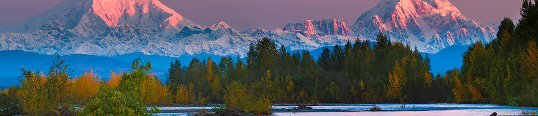
Hundreds of mountains jut out of the plains of the Alaskan wilderness, towering high above forests, towns and roads. Many dream of driving along some of the state’s most famous highways, feeling humbled by the majestic peaks. With four major mountain ranges including the Alaska Range, the Coast Range, the Brooks Range and the Aleutian Range, avid climbers will be spoiled for choice. Whether you’re eager to summit or just want to take in the views, here’s a guide to Alaska’s tallest mountains from smallest to largest:
Mount Blackburn
How tall is Mount Blackburn?
Can I climb Mount Blackburn?
Yes, there are four main routes to the summit of Mount Blackburn. The North Ridge, East Ridge, Southeast Ridge and South and Southwest Ridge. While the first three are all used regularly, there has been no successful summit via the South and Southwest Ridge so far due to severe weather, crevasses and avalanches.
The history of Mount Blackburn
Mount Blackburn is the highest peak in the Wrangell Mountain Range and is the fifth-highest peak in the United States. It is also an old, eroded shield volcano and the second-highest volcano in the US. It was named by Henry T. Allen of the US Army in 1885 after Joseph Clay Stiles Blackburn, a US senator from Kentucky.
Kennedy Peak or East Blackburn is the eastern summit which was originally thought to be the highest point of the mountain. The first ascent of this summit was made in 1912 by George Handy and Dora Keen.
How can I see Mount Blackburn?
Mount Blackburn is in the heart of Wrangell-St Elias National Park and Reserve. The best way to catch a glimpse of the mountain is by driving on the road to McCarthy.
Mount Bona
How tall is Mount Bona?
Can I climb Mount Bona?
Yes, the most common route is via the East Ridge. It is considered by some to be the ideal stepping stone before tackling a bigger and more complicated peak such as Denali. However, Mount Bona isn’t an easy mountain to climb, with glaciers and rapidly changing weather often hampering expeditions.
The history of Mount Bona
Mount Bona was named by Prince Luigi Amedeo, Duke of the Abruzzi, in 1897. He allegedly saw the peak while making the first ascent to Mount Saint Elias, which is around 80 miles away, and named it after his racing yacht. The spectacular mountain was first climbed in 1930 by Allen Carpe, Terris Moore and Andrew Taylor. Instead of the most popular route today, the climbers scaled the Russel Glacier on the west of the peak.
How can I see Mount Bona?
The mountain can be found in Wrangell-St Elias National Park and Reserve, so McCarthy is the closest town.
Mount Foraker
How tall is Mount Foraker?
Can I climb Mount Foraker?
Yes, many expeditions run for eager climbers and hikes to summit parts of Mount Foraker. The first successful ascent was completed in 1934 by Charles S. Houston, Dr T. Graham Brown and Chychele Waterson via the northwest ridge. Since then, there have been many notable climbs and some fatalities.
The history of Mount Foraker
As the sixth tallest mountain in North America, Mount Foraker stands proudly in the Alaska Range in Denali National Park. Although still named ‘sultana’ by native Alaskans, meaning ‘the woman,’ the mountain was officially named after Joseph B. Foraker, a sitting US Senator at the time from Ohio.
How can I see Mount Foraker?
Mount Foraker can be found in Denali National Park. Your best bet is to take the historic Petersville Road.
Mount Saint Elias
How tall is Mount Saint Elias?
Can I climb Mount Saint Elias?
No, it’s not advisable. Although the mountain is sometimes climbed, there is no easy route to the summit and long stretches of bad weather often hamper attempts to climb.
The history of Mount Saint Elias
Mount Saint Elias is the second-highest mountain in the US and Canada, set on the Yukon and Alaska border. It forms part of the Saint Elias Mountains. Its name in Tlingit (a language spoken by the Tlingit people of Southeast Alaska) is Yas’eit’aa, meaning ‘mountain behind icy bay.’ It is said that Mount Saint Elias and Mount Fairweather at the border of British Columbia and Alaska were originally next to each other but had an argument and separated.
The mountain is most famous for its vertical relief, with its summit rising 18,000 feet vertically in just 10 miles. In 2007, an Austrian documentary film was made about a team of skiers and mountaineers who wanted to make the planet’s longest skiing descent. The team summited and then successfully skied down to 13,000 ft.
How can I see Mount Saint Elias?
Mount Saint Elias sits in the Wrangell-St Elias National Park and Reserve. At 13.2 million acres, the park is the same size as Yellowstone, Yosemite and Switzerland combined. To get anywhere near the mountain, your best bet is to go via the town of McCarthy.
Denali
How tall is Denali?
Can I climb Denali?
Yes but it’s not easy. The first recorded attempt was in 1903 by Judge James Wickersham. He ascended via the Peters Glacier and the North Face, which is now known as the Wickersham Wall. It was unsuccessful and over the years, a series of dangerous avalanches prevented the mountain from being summited until 1963. Today, people regularly climb Denali, though many have died over the years trying to scale it.
The history of Denali
Denali, also known as Mount McKinley, is the highest mountain peak in North America. This imposing mountain is also the third most isolated peak in the world, after Mount Everest and Aconcagua. The Koyukon (native Alaskan) people who inhabit the area surrounding the mountain have named the peak ‘Denali’ for centuries. In 1896, a gold prospector named it Mount McKinley in support of the presidential candidate at the time, William McKinley. Regardless of its name, its beauty is undisputed.
How can I see it?
Denali is visible from various locations in Alaska, including Denali Park Road, Anchorage, Fairbanks and the George Parks Highway.